-
orwaca_iads
orwaca_iads
|
|
UNCLASSIFIED
Any resemblance or approximations to actual weapon system capabilities
in this demo are purely accidental. The intent of this DEMONSTRATION is
to illustrate how to setup an integrated air defense system (IADS).
There are two start up files.
The startup file “orwaca_northern_area.txt” only has the sams in the states of Washington and Oregon.
The startup file “orwaca_full_area.txt” has the additional SAMs located in the state of California
You must use the new icons that have “_icon” in the name or all of the platforms will look like stop signs when
looking at output files in Mystic.
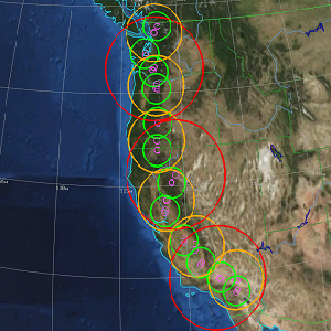
The “orwaca_full_iads_coverage.JPG” image file (located in jpg subdirectory) shows the geographical locations
of the sam sites.
The extremely long range sams (ELR_SAMS) are 175 nautical mile missiles (RED rings)
The long range sams (LR_SAMS) are 100 nautical mile missiles (ORANGE rings)
The medium range sams (MR_SAMS) are 50 nautical mile missiles (GREEN rings)
The SR_SAMS are 10 nautical mile missiles (VIOLET rings) (max alt of 15kft)
(they don’t do so well past 7 nautical miles so can be defeated at longer kinematic ranges)
The SR_SAMS (telars) are self commanded and do not do cooperative engagements like the longer range sams.
The TBM shooting at Denver can be adjusted to shoot at any time during the simulation run.
This can be accomplished by adjusting the times in platforms/tbm_launcher_vehicle.txt (for every tbm launcher) OR
adjusting the platform variables in the scenario file “tbm_route_launch.txt”.
This is just an example to show some scripting capability. The pause time in the route has to be adjusted accordingly.