Projector - Mystic
Sensor projections can be shown on the Map Display to visualize instantaneous sensor coverage as affected by terrain.
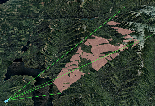
The projector will color the parts of the terrain that are visible to the sensor.
Limitations
Projections make use of the displayed visual terrain database, not the simulation’s loaded terrain. The accuracy of the display is affected by the currently displayed level of detail.
Projections will hide when the loaded terrain changes.
Projections can only be viewed for sensors that have a rectangular field-of-view that is symmetric about the bore-sight.
Neither azimuth nor elevation field-of-view may not exceed 135 degrees.
Projections have a range from 100 m to 7000 km. Anything outside this range will not be effected by nor effect the projection.